


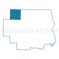
Louisville Voting District, Lincoln County, Missouri
About
Outline

Summary
| Unique Area Identifier | 608972 |
| Name | Louisville Voting District |
| County | Lincoln County |
| State | Missouri |
| Area (square miles) | 38.37 |
| Land Area (square miles) | 38.01 |
| Water Area (square miles) | 0.36 |
| % of Land Area | 99.06 |
| % of Water Area | 0.94 |
| Latitude of the Internal Point | 39.18662230 |
| Longtitude of the Internal Point | -91.13490200 |
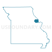
Maps

Graphs
Select a template below for downloading or customizing gragh for Louisville Voting District, Lincoln County, Missouri


Neighbors
Neighoring Voting District (by Name) Neighboring Voting District on the Map
- Ashley NO/Hartford PQ Voting District, Pike County, MO
- Cuivre JL Voting District, Pike County, MO
- Millwood Voting District, Lincoln County, MO
- Olney Voting District, Lincoln County, MO
- Prairieville I Voting District, Pike County, MO
- Silex Voting District, Lincoln County, MO
- Whiteside Voting District, Lincoln County, MO
Top 10 Neighboring County Subdivision (by Population) Neighboring County Subdivision on the Map
- Cuivre township, Pike County, MO (7,298)
- Union township, Lincoln County, MO (2,833)
- Prairieville township, Pike County, MO (1,042)
- Millwood township, Lincoln County, MO (918)
- Hartford township, Pike County, MO (533)
- Ashley township, Pike County, MO (519)
- Waverly township, Lincoln County, MO (412)
- Nineveh township, Lincoln County, MO (346)
Top 10 Neighboring Unified School District (by Population) Neighboring Unified School District on the Map
- Bowling Green R-I School District, MO (11,119)
- Pike County R-III School District, MO (2,957)
- Silex R-I School District, MO (2,565)